Drone technology is widely use in Industries like Mining, Power, Highway, Railway, Critical Infrastructure, Urban & Regional Planning etc. Surveying & Mapping with a drone offers enormous potential to GIS professionals. Using drone technology, it is possible to carry out topographic surveys with high quality & highly accurate measurements collected in a fraction of the time. This substantially reduces the cost and time of a site survey. Orthomosaic and digital surface model created from aerial images taken by surveying and mapping Drone.
What is Drone Survey?
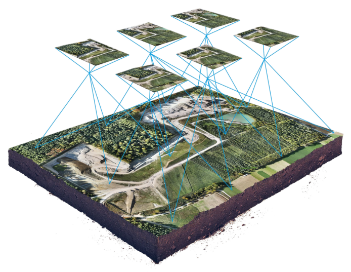
A drone survey refers to the use of a drone, or unmanned aerial vehicle (UAV), to capture aerial data with downward-facing RGB camera. During a drone survey the ground is photographed several times from different angles, with number of overlapped images and each image is geo-tagged. From this data, a photogrammetry software can create geo-referenced orthomosaics, elevation models or 3D models of the project area. These maps can also be used to extract information such as highly-accurate distances or volumetric measurements. Unlike manned aircraft or satellite imagery, drones can fly at a much lower altitude, making the generation of high-resolution, high-accuracy data, much faster, less expensive and independent of atmospheric conditions such as cloud cover.
Uses of Drone in Surveying
Land Surveying
Survey drones generate high-resolution orthomosaics and detailed 3D models of areas where low-quality, outdated or even no data, are available. They thus enable high-accuracy cadastral maps to be produced quickly and easily, even in complex or difficult to access environments. Surveyors can also extract features from the images, such as signs, curbs, electric arrangements, road markers, fire hydrants, communication towers, Buildings, Open lands and drains. After post-processing with a photogrammetry software, these same images can produce very detailed elevation models, contour lines and break lines, as well as 3D reconstructions of land sites or buildings.
Land Management and Development
Aerial images taken by drones greatly accelerate and simplify topographic surveys for land management and planning. This helps for Pre-construction planning and construction monitoring. This holds true for site scouting, allotment planning and design, as well as final construction of roads, buildings and utilities. These images also provide the foundation for detailed models of site topography for pre-construction engineering studies. The generated data can also be transferred to any CAD or BIM software so that engineers can immediately start working from a 3D model. As data collection by drones is easily repeatable at low cost, images can be taken at regular intervals and overlaid on the original blueprints to assess whether the construction work is moving according to plan specifications.
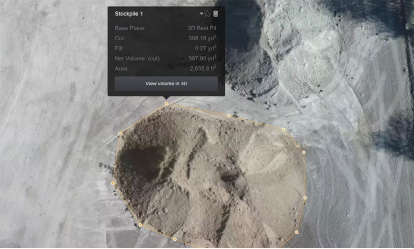
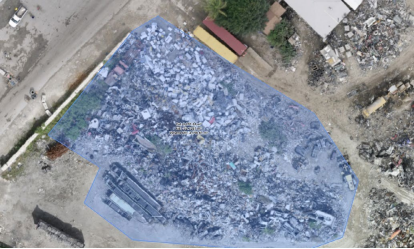
Stockpile Volumetric Measurements
High resolution orthophotos enable surveyor to perform highly accurate distance and surface measurement. With photogrammetry software, it is also possible to obtain volumetric measurements from the very same images. This fast and inexpensive method of volume measurement is particularly useful to calculate stocks in mines and quarries for inventory or monitoring purposes. Surveying can capture and depict all these variations as shape’s actual volume, and not just its estimate. We strategically and efficiently deliver photogrammetric information through Contouring, Digital Surface Models, stockpiles such as waste, mines, inventory, agriculture, etc., and volume measurements with a nearly 99% accuracy rate. With a drone, surveyors can capture many more topographic data points, hence more accurate volume measurements.
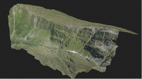
Slope Monitoring
With automated GIS analysis, it is possible to extract slope measurements from DTMs and DSMs generated by drone imagery. Knowing the steepness of the ground’s surface, the areas can be classified and used for slope monitoring purposes, including landslide mitigation and prevention. With orthomosaics taken at different times, it is possible to detect changes in earth movement and to measure its velocity. This data can help predict landslides and prevent potential damage to roads, railways and bridges. Compared to traditional monitoring techniques, where sensors are placed on single points, drones enable more comprehensive data collection. Drones with PPK capability, which do not require laying out of multiple GCPs, are optimal for this application, since these areas are often hard to reach or even dangerous.
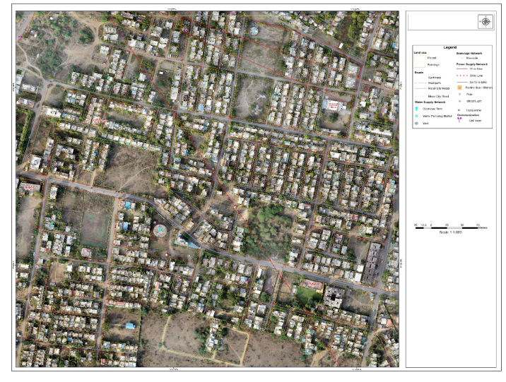
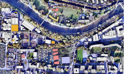
Urban Planning
The development of dense and complex areas requires intensive planning and therefore time-consuming and expensive data collection. Thanks to drones, urban planners can collect large amounts of up-to-date data in a short period of time and with far less staff. The images produced in this way allow planners to examine the existing social and environmental conditions of the sites and consider the impact of different scenarios.
Benefits of Drone Surveying
Map otherwise inaccessible areas
An aerial mapping drone can take off and fly almost anywhere. You are no longer limited by unreachable areas, unsafe steep slopes or harsh terrain unsuitable for traditional measuring tools. You do not need to close down highways or train tracks. In fact, you can capture data during operation without an organizational overhead
Provide accurate and exhaustive data
Total stations only measure individual points. One drone flight produces thou- sands of measurements, which can be represented in different formats (ortho- mosaic, point cloud, DTM, DSM, contour lines, etc). Each pixel of the produced map or point of the 3D model contains 3D geo-data.
Reduce field time and survey costs
Capturing topographic data with a drone is up to five times faster than with land-based methods and requires less manpower. With PPK geo-tagging, you also save time, as placing numerous GCPs is no longer necessary. Your ultimately deliver your survey results faster and at a lower cost.